Property boundary survey Vancouver Island represents essential investment protecting property ownership clarity, preventing costly neighbor disputes, and enabling confident development planning. Rural properties frequently feature unclear boundaries—old surveys (50+ years), missing monuments, overlapping deeds—creating ambiguity requiring professional clarification before purchase, development, or fence installation.
Real estate expert Andrew Hrushowy emphasizes that property boundary confusion causes disproportionate rural damage—neighbor disputes over fence placement, encroachments going unnoticed for years, development projects discovering boundary conflicts creating expensive delays and legal costs. Strategic boundary survey investment prevents these complications while establishing clear legal ownership supporting long-term satisfaction and property security. This comprehensive guide addresses survey types, cost factors, interpretation frameworks, and strategic timing enabling confident boundary clarity aligned with property objectives.
Professional boundary surveys establishing legal property lines prevent costly disputes and protect ownership clarity supporting long-term property security and satisfaction.
Key Takeaways
- Survey Cost Variability: BC boundary surveys typically $1,500-$3,500 depending on property size, accessibility, record availability; rural/remote properties cost more due to access difficulty and limited historical records.
- Licensed Surveyor Requirement: Only Professional Land Surveyors (PLS) licensed by BC can conduct legally-recognized surveys; DIY surveys useless for legal purposes; professional credentials essential for legal validity.
- Pre-Purchase Survey Critical: Boundary verification before purchase prevents discovering post-closing conflicts requiring expensive corrections; identifies encroachments, easements, restrictions before commitment.
- Monument Verification Essential: Surveys confirm boundary monuments (original markers) existence; missing/moved monuments require reconstruction from historical records, increasing costs and timeline.
- Andrew Hrushowy strongly recommends boundary surveys before any rural property purchase, fence installation, or development; survey costs minimal compared to dispute litigation ($20,000-$100,000+ typical legal costs).
Overview
Rural property boundary surveys require professional expertise, understanding cost factors, and strategic timing ensuring maximum value and legal clarity. Andrew Hrushowy identifies that many rural buyers skip surveys attempting cost savings; this false economy frequently results in post-purchase complications costing multiples of survey investment. This supporting blog synthesizes survey fundamentals, cost considerations, and strategic positioning enabling confident boundary clarity supporting property security and long-term satisfaction.
For comprehensive rural property guidance, explore our February 2026 Farms for Sale guide, rural property inspection checklist, and acreages for sale in Cowichan Valley guides.
| Survey Type | Purpose | BC Cost Range | Timeline | Best Used For |
|---|---|---|---|---|
| Boundary Survey | Determine property lines, corner locations, legal boundaries | $1,500–$3,500 | 2–6 weeks | Purchase, property disputes, fence installation |
| Mortgage/Lending Survey | Confirm boundaries for lender requirements; simplified version | $1,200–$2,500 | 1–3 weeks | Mortgage pre-approval, existing property verification |
| Topographic Survey | Map elevations, slopes, drainage patterns, site features | $2,000–$6,500 | 3–8 weeks | Development planning, drainage analysis, construction prep |
| Fence Line Survey | Identify boundary for fence installation; confirms neighbor agreement | $1,000–$3,200 | 2–4 weeks | Fence installation, property line clarification with neighbors |
| Encroachment Survey | Identify structures crossing boundaries, easements, violations | $1,500–$4,000 | 2–6 weeks | Neighbor disputes, boundary encroachment resolution |
| Subdivision Survey | Divide property into multiple lots with separate legal descriptions | $2,500–$8,000+ | 6–12 weeks | Lot creation, property division, development |
| Title Survey | Comprehensive boundary documentation for title assurance; highest accuracy | $2,000–$5,000 | 3–8 weeks | Title insurance, comprehensive legal documentation |
Understanding Boundary Survey Fundamentals
What Is a Boundary Survey?
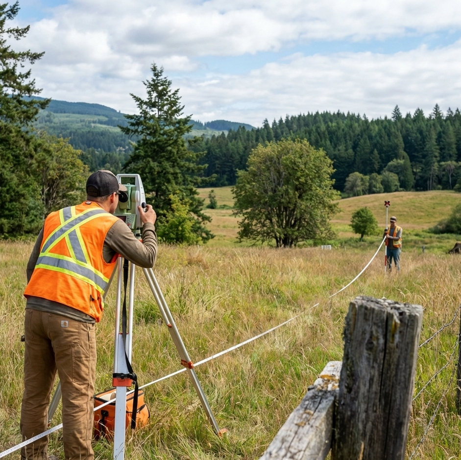
A boundary survey represents professional determination of property legal boundaries using historical records (deeds, previous surveys, legal descriptions), physical markers (original monuments, permanent improvements), and advanced surveying technology (GPS, total stations) establishing exact property corners and lines.
Survey Components:
- Corner Identification: Locating and documenting all property corners (4 for rectangular lots; more for irregular shapes)
- Boundary Line Documentation: Marking exact lines between your property and neighbors’ properties
- Encroachment Identification: Revealing structures crossing property lines (fences, driveways, buildings)
- Easement Documentation: Identifying utility rights of way, water access, other easements affecting property
- Legal Description: Written description matching deed and title documentation
Licensed Professional Requirement
Only Professional Land Surveyors (PLS) licensed by BC can conduct legally-recognized surveys; non-licensed individuals may perform measurements but results lack legal validity.
BC Licensing Requirements:
- University degree in surveying or related field
- Professional examination passing (BC Land Surveyor examination)
- Liability insurance and bonding requirements
- Continuing professional development obligations
- Professional stamp required on all survey documents
Verification: Check Association of BC Land Surveyors directory confirming surveyor licensing status before hiring.
Cost Factors and Budget Planning
Property Size and Shape
Simple Rectangular Properties: 1-5 acres, standard rectangular shape, visible boundaries—typical cost $1,500-$2,500
Complex or Large Properties: 10+ acres, irregular boundaries, hidden/unclear lines—typical cost $2,500-$4,000+
Rule of Thumb: Budget $300-$700 per acre for typical rural properties; remote/difficult-access properties cost more.
Location and Accessibility
Urban/Developed Areas: Easy surveyor access, complete historical records, standard monuments—lower costs ($1,200-$2,000)
Rural Properties: Limited access, mountain terrain, island locations—higher costs due to travel time and equipment requirements ($2,000-$4,000+)
Remote/Island Properties: Special ferry requirements, difficult terrain, minimal record availability—highest costs ($3,000-$6,000+)
Andrew Hrushowy advises rural buyers obtaining preliminary survey cost estimates during property evaluation, budgeting accordingly before commitment.
Record Availability and Research
Recent Survey (0-10 years): Existing records, clear monuments, established lines—faster approval ($1,500-$2,500)
Older Survey (10-50+ years): Records require research, monuments may be missing, reconstruction needed—extended timeline ($2,000-$3,500)
No Survey History: Extensive record research, monument reconstruction from historical documentation—significant costs/timeline ($3,000-$5,000+)
Research Fees: Additional $200-$500 charged if surveyor must conduct extensive record research beyond standard process.
Survey Type and Complexity
Basic Boundary Survey: Property corners and lines only ($1,500-$2,500)
Detailed Boundary Survey with Encroachments: Includes existing structures, easements, violations ($2,000-$3,500)
Topographic Survey: Adds elevation mapping, drainage analysis, site feature documentation ($3,000-$6,500)
Subdivision Survey: Creates multiple legal lots; requires municipal coordination ($3,500-$8,000+)
Strategic Survey Timing and Process
Pre-Purchase Survey (Recommended)
Timing: Before offer submission or at minimum before closing; identifies concerns enabling renegotiation or exit
Process:
- Surveyor Selection: Obtain quotes from 2-3 local surveyors; confirm licensing and experience
- Survey Scope Definition: Specify basic boundary survey (most rural purchases need standard boundary survey)
- Quote Request: Provide property legal description, address, access information
- Document Gathering: Surveyor obtains historical records, locates previous survey markers
Timeline: 4-8 weeks typical; rush services available (+$300-$500 premium)
Value: Identifies boundary issues before purchase preventing post-closing complications; enables price negotiation if problems discovered
Development Planning Survey
Timing: Before construction planning; provides accurate site information for design
Scope: Boundary survey plus topographic survey (elevations, drainage, existing features)
Value: Construction project planning depends on accurate boundary/topographic data; prevents building code violations, encroachments, or expensive relocations
Fence Installation Survey
Timing: Before fence construction; confirms neighbor agreement prevents expensive corrections
Scope: Fence-specific boundary survey establishing exact fence line location
Cost: $1,000-$3,200 typical; lower cost than comprehensive boundary survey
Value: Prevents neighbor disputes over fence placement; legal protection if neighbor objects
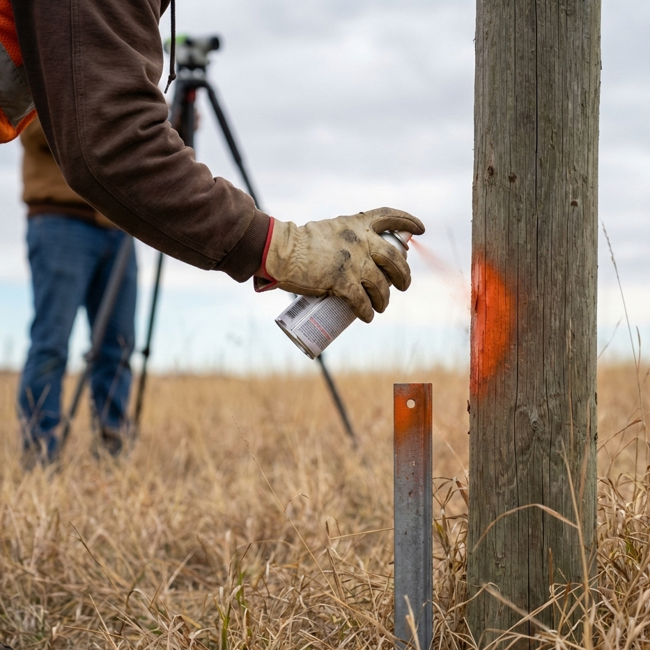
Monument Understanding and Boundary Markers
Original Monuments
Property boundaries established through original monuments—physical markers placed when land originally surveyed (often 50-100+ years ago). These monuments represent foundational boundary evidence.
Monument Types:
- Steel Posts: Iron rods driven into ground at corners
- Stone Markers: Natural/quarried stone at property corners
- Brass Caps: Metal caps identifying survey points
- Concrete Posts: Modern monuments set at boundaries
Monument Challenges
Missing Monuments: Original markers may have disappeared through land disturbance, erosion, neighbor removal—requires reconstruction from historical records (time-consuming, expensive)
Moved Monuments: Neighbors may have inadvertently moved markers; surveyor must reconstruct based on original descriptions
Unclear/Ambiguous Records: Old deeds contain vague descriptions (“100 rods from oak tree”) requiring interpretation and research
Multiple Surveys Conflict: Different surveys over years may contain contradictions requiring arbitration and historical analysis
Andrew Hrushowy emphasizes that missing monuments significantly increase survey costs and timelines; properties with original monuments visible and accessible enable faster, cheaper surveys.
Interpreting Survey Results and Legal Documentation
Survey Map Components
Professional survey maps include:
- Property Boundaries: Exact lines defining your property (typically colored red)
- Corner Locations: Marked with symbols; coordinates provided
- Structures: All buildings, fences, driveway positions shown
- Encroachments: Any neighbors’ structures crossing your line identified
- Easements: Utility rights, water access, other easements marked
- Legal Description: Written description matching deed and title documents
Understanding Encroachments
Survey may reveal encroachments—neighbor structures crossing your property line:
- Minor Encroachments: Small fence portions, landscaping features typically resolved through negotiation or written agreement
- Significant Encroachments: Buildings, driveways, substantial structures may require legal action, forced removal, or negotiated compensation
- Mutual Encroachments: Your structures may encroach on neighbor property; reciprocal negotiations typical
Andrew Hrushowy advises discussing encroachments with surveyor and lawyer before taking action—often negotiated solutions preferred over expensive legal battles.
Easement Documentation
Survey reveals easements—legal rights allowing others to use portion of your property:
- Utility Easements: Power lines, water pipes, sewer lines (typically 10-20 feet wide; standard for rural properties)
- Access Easements: Neighbor rights to cross your property reaching landlocked property
- Water Rights: Water access across property, spring development rights
- Agricultural Easements: Conservation restrictions limiting future development
Understanding: Easements permanently restrict property use; disclosed on title; transfer with ownership; typically cannot be removed without court action.
Common Boundary Dispute Prevention Strategies
Strategy 1: Pre-Purchase Verification
Conduct boundary survey before purchase; eliminates post-closing surprises; enables informed decision-making.
Strategy 2: Clear Documentation
Maintain survey copies in organized files; provide copies to lawyer and lender; reference in deeds and legal documents.
Strategy 3: Neighbor Communication
Discuss property lines with neighbors; resolve disagreements before legal escalation; consider shared survey costs ($400-$600 per party savings).
Strategy 4: Marker Maintenance
Keep boundary monuments visible; mark corners with painted posts or signs; prevents neighbor encroachments through ignorance.
Strategy 5: Updated Surveys
Conduct new survey every 20-30 years ensuring continued accuracy; particularly important before major development or sales.
Ready to establish property boundary clarity protecting Vancouver Island rural property ownership? Andrew Hrushowy—with comprehensive boundary survey guidance and dispute prevention expertise—helps buyers ensure legal clarity supporting long-term property security. Contact Andrew Hrushowy at 755 Humboldt St, Victoria, BC V8W 1B1 or call (250) 383-1500 for expert boundary survey consultation and legal guidance.
For comprehensive rural property resources, explore our February 2026 Farms for Sale guide, rural property inspection checklist, acreages for sale in Cowichan Valley, and preparing land for first-time farming guides.
FAQs
Q: How much does boundary survey cost in BC?
A: Typically $1,500-$3,500 depending on property size, accessibility, record availability; rural/remote properties cost more.
Q: Is survey required for property purchase?
A: Not legally required; however, strongly recommended to prevent boundary disputes and ownership clarity issues post-purchase.
Q: Can I dispute survey results if I disagree?
A: Yes—surveys can be reviewed by other licensed surveyors; if disputes exist, courts may require new independent survey; rare for professional surveys to be incorrect.
Q: What if old survey exists; do I need new one?
A: Surveys older than 20 years may lack accuracy; recommend new survey especially if monuments missing or records unclear.
Q: How long does boundary survey take?
A: Typically 4-8 weeks; rush services available; timeline depends on record availability and property accessibility.
Conclusion
Rural property boundary surveys represent essential investment protecting ownership clarity, preventing costly disputes, and enabling confident development planning. Andrew Hrushowy emphasizes that survey costs—typically $1,500-$3,500—represent minimal investment compared to boundary dispute litigation ($20,000-$100,000+ typical legal costs).
Professional surveys conducted by licensed BC land surveyors establish legal boundary clarity through comprehensive historical research, physical monument verification, and professional documentation enabling confident property ownership supporting long-term satisfaction and security. Strategic survey timing (pre-purchase, before development, before fence installation) maximizes value preventing post-purchase complications requiring expensive corrections.